Startseite » English » Ukraine »
ShakeMap (Calculated intensity of the earthquake in Crimea Peninsula):

View earthquake, ShakeMap and historical seismicity on interactive map
Earthquake summary
A rather powerful earthquake rattled parts of the Crimea Peninsula in the Black Sea early Thursday morning. According to the Ukrainian Seismological Service, the quake reached a magnitude of 4.8, making it the strongest earthquake in the region since 2008. The epicenter was approximately 60 kilometers from the southern tip of the peninsula, causing noticeable tremors, particularly in the port city of Sevastopol (Intensity III to IV). However, damage resulting from the earthquake is not expected.
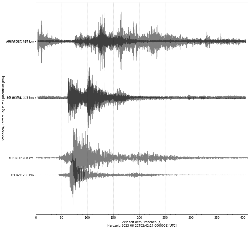
Seismological records from surrounding stations show clear characteristics of a natural earthquake. This confirms that it was a tectonic event and not related to any potential military operations (weapons testing, etc.).
The Crimea Peninsula is one of the most seismically active regions in Eastern Europe. It is located within a fault zone that extends from Romania to the Caucasus, where light earthquakes occur frequently. Also stronger shocks are part of the earthquake history of the Crimea peninsula. In 1927, a magnitude 6.8 earthquake hit the peninsula, causing devastating damage, especially in Sevastopol. Several people were killed. A similar quake occurred in 1341.
[irp]
Affected places
| City | Country | Intensity (EMS-98) | Population | Distance epicenter (km) | Description |
|---|---|---|---|---|---|
| Shturmovoye | UA | 3.7 | 1500 | 61.3 | weak |
| Sevastopol | UA | 3.6 | 464300 | 63.8 | weak |
| Sakharnaya Golovka | UA | 3.6 | 4100 | 63.5 | weak |
| Orlinoye | UA | 3.5 | 2100 | 54.3 | weak |
| Inkerman | UA | 3.4 | 10200 | 65.9 | weak |
| Ternovka | UA | 3.4 | 1800 | 66.1 | weak |
| Bakhchysarai | UA | 3.0 | 27400 | 87.4 | weak |
| Saki | UA | 2.9 | 28300 | 122.6 | barely felt |
| Molodyozhnoye | UA | 2.8 | 7600 | 119.1 | barely felt |
| Mirnoye | UA | 2.8 | 9300 | 117.3 | barely felt |
Current earthquake activity near Sevastopol:
In Shturmovoye (map) 10 earthquakes larger than 4.2 were detected over the past 30 days. Therefore, the earthquake activity over the past month was much higher than usual (more than 20 % difference).
Summary of earthquake data:
FAQ: What are earthquakes? Which earthquakes are dangerous? How can you protect your famility and property?
What are faults and plates? Important terms explained.
General information about this earthquake:
Time: 2023-06-22 02:42 UTC
Magnitude: 4.8
Depth: 10 km
Felt: yes
Damage expected: --
Fatalities expected: --
Origin: tectonic
Links to all earthquake surveys in the world
Check out our Earthquake Impact Database to get all data for recent damaging earthquakes.
Earthquake data: MCSM
Statistic:
Since 1960 19 earthquakes larger than Magnitude 4.0 were detected in this region. The average number of earthquakes in this part of Ukraine (near Sevastopol) is 0.33 quakes larger than 4.0 per year. Therefore, the seismicity is usually low and quakes of magnitude 4.8 have a recurrence period of approx. 19.1 years (229 months).
Strongest earthquakes in this area
| Date | Magnitude | Depth (km) |
|---|---|---|
| 2023-06-22 02:42 | 4.7 | — |
| 2001-03-04 23:30 | 4.6 | — |
| 1990-08-16 04:32 | 4.6 | — |
| 1991-07-25 08:26 | 4.6 | — |
| 2020-04-12 02:31 | 4.4 | — |
| 1986-03-03 07:26 | 4.4 | — |
| 1977-12-23 07:31 | 4.4 | — |
| 1998-10-18 05:22 | 4.3 | — |
| 1998-10-16 15:24 | 4.3 | — |
| 2001-07-29 22:30 | 4.2 | — |
*Data: USGS-Catalog (since 1960)