Startseite » English » Indonesia »
ShakeMap (Calculated intensity of the earthquake in Indonesia):
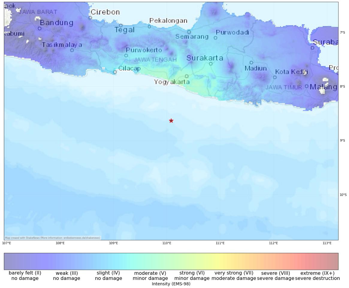
View earthquake, ShakeMap and historical seismicity on interactive map
Earthquake summary
Strong earthquake of M6.4 hit the Indonesian main island of Java. region of Yogyakarta, Indonesia. According to BMKG, the earthquake occurred at a depth of 25km, and the epicentre was in the Sea 86 Km Southwest of Bantuland and around 100 km south of the city of Yogjakarta. The tremors were felt extensively throughout Bali and Java. The intensity of the earthquake reached a level of V-VI on the European Macroseismic Scale (EMS-98). which suggests that there is a slight likelihood of infrastructure damage due to the higher intensity.
There is no danger of a tsunami due to the earthquake. The subduction zone off the south coast of Java is the source of this earthquake, and it is one of the world’s most active plate boundaries.
Update 16:07
Reports surfaced on social media of several houses sustaining damage in Yogjakarta. Images and videos showed cracks in the walls and ceilings of the affected houses. Fortunately, there have been no reports of injuries so far. Residents in Pacitan also reported damage to several houses, with some partially collapsed.
Gempa Bantul mengakibatkan tembok ambruk di daerah Bangunjiwo Kasihan Bantul#gempa pic.twitter.com/hWh1TKWDPI
— Gelandang Pengatur Skor (@Thitipan_Mafia) June 30, 2023
[irp]
Affected places
| City | Country | Intensity (EMS-98) | Population | Distance epicenter (km) | Description |
|---|---|---|---|---|---|
| Srandakan | ID | 5.9 | 29500 | 78.7 | moderate, very minor damage |
| Bambanglipuro | ID | 5.9 | 44700 | 78.5 | moderate, very minor damage |
| Pandak | ID | 5.8 | 56000 | 82.7 | moderate, very minor damage |
| Sewon | ID | 5.7 | 73600 | 88.8 | moderate, very minor damage |
| Bantul | ID | 5.7 | 58700 | 86.5 | moderate, very minor damage |
| Yogyakarta | ID | 5.5 | 636700 | 96.9 | moderate, very minor damage |
| Surakarta | ID | 4.9 | 555300 | 144.8 | slight |
| Purwokerto | ID | 4.6 | 217200 | 163.0 | slight |
| Madiun | ID | 4.4 | 186100 | 193.8 | slight |
| Pekalongan | ID | 4.4 | 257900 | 197.7 | slight |
Current earthquake activity near Srandakan:
In Srandakan (map) 1320 earthquakes larger than 4.5 were detected over the past 30 days. Therefore, the earthquake activity over the past month was much higher than usual (more than 20 % difference).
Summary of earthquake data:
FAQ: What are earthquakes? Which earthquakes are dangerous? How can you protect your famility and property?
What are faults and plates? Important terms explained.
General information about this earthquake:
Time: 30-06-23 12:47 UTC
Magnitude: 6.4
Depth: 25 km
Felt: yes
Damage expected: --
Fatalities expected: --
Origin: tectonic
Tsunami: --
Links to all earthquake surveys in the world
Check out our Earthquake Impact Database to get all data for recent damaging earthquakes.
Earthquake data: BMKG
Statistic:
Since 1960 2640 earthquakes larger than Magnitude 4.0 were detected in this region. The average number of earthquakes in this part of Indonesia (near Srandakan) is 44.02 quakes larger than 4.0 per year. Therefore, the seismicity is usually very high and quakes of magnitude 6.4 have a recurrence period of approx. 5.7 years (68 months).
Strongest earthquakes in this area
| Date | Magnitude | Depth (km) |
|---|---|---|
| 1994-06-02 18:17 | 7.8 | 18 |
| 2006-07-17 08:19 | 7.7 | 20 |
| 2009-09-02 07:55 | 7.0 | 46 |
| 2013-06-13 16:47 | 6.7 | 9 |
| 2011-04-03 20:06 | 6.7 | 14 |
| 1998-09-28 13:34 | 6.6 | 152 |
| 1994-06-03 21:06 | 6.6 | 26 |
| 1985-10-09 01:15 | 6.5 | 154 |
| 2017-12-15 16:47 | 6.5 | 90 |
| 1974-09-07 20:43 | 6.5 | 33 |
*Data: USGS-Catalog (since 1960)