Startseite » English » Mexico »
ShakeMap (Calculated intensity of the earthquake in Mexico, Guatemala):
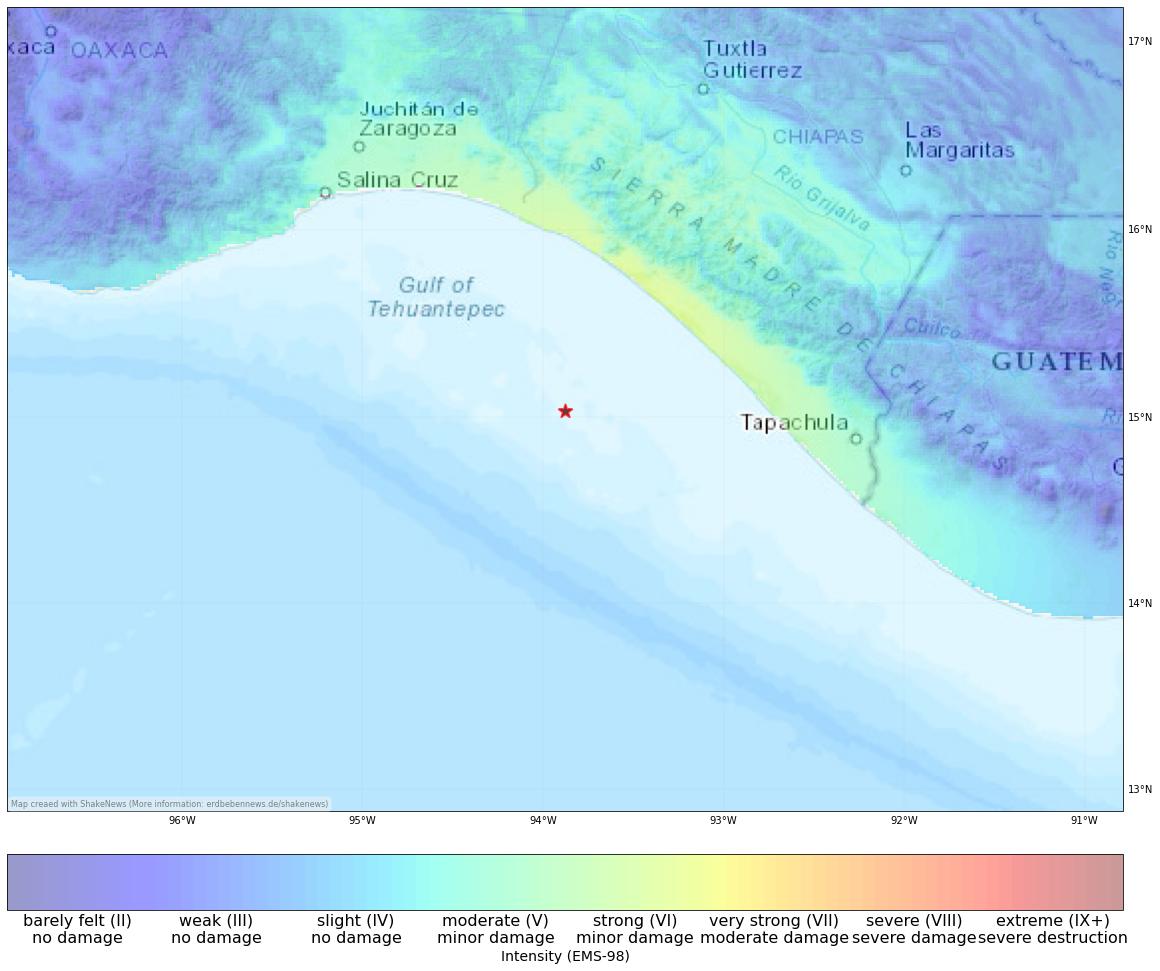
View earthquake, ShakeMap and historical seismicity on interactive map
Affected population
The earthquake with magnitude 6.3 occurred on 2023-07-14 09:29 UTC near Manuel Ávila Camacho (Ponte Duro), Mexico. Erdbebennews calculates a maximum intensity of nan for this earthquake. In populated areas, the earthquake reached a maximum intensity of 6.7. Up to 2.7 mio people (in the map area) have felt this earthquake. Among them, 2.7 mio people live in regions with light or moderate shaking, where no significant damage is expected. -2 people live in areas where potential damage to buildings can occur, including 0 in areas with possible severe damage and destruction.
| Intensity | 2 | 3 | 4 | 5 | 6 | 7 | 8 | 9 | 10 |
|---|---|---|---|---|---|---|---|---|---|
| affected people | 1k | 90k | 2.2 mio | 387k | 0 | 0 | 0 | 0 | 0 |
| Intensity | effects | affected people |
|---|---|---|
| 2 – 5.5 | Felt shaking | 2.7 mio |
| 5.5 – 6.5 | Minor damage | 0 |
| 6.5 – 8 | Moderate damage | 0 |
| 8 – 10 | Severe damage | 0 |
Earthquake Summary
Strong earthquake of M6.3 hit the coast of the Mexican state of Chiapas. According to USGS, the earthquake occurred at a depth of 35km, and the epicentre was in the Sea 87 Km off the coast SW of El Palmarcito. The tremors were felt extensively throughout southern Mexico and in neighbouring regions of Guatemala and Belize. The earthquake’s intensity reached a level of V-VI on the European Macroseismic Scale (EMS-98) around Chiapas and the state of Oaxaca. This suggests a likelihood of minor infrastructure damage due to the higher intensity.
There is no danger of a tsunami as a result of this earthquake. It is possible that this earthquake is an aftershock of the Great Chiapas earthquake that occurred in September 2017, which caused a fault rupture in the subducted Cocos Plate, which dips beneath the North American and Caribbean Plates off the Pacific coast of Mexico. The quake inflicted severe damage in Chiapas and Oaxaca, as well as in neighbouring states, resulting in the loss of 102 lives and leaving almost 500,000 people homeless. Despite the extent of the devastation, the event received little attention nationally and internationally. Just two weeks later, a 7.1 magnitude earthquake near the Mexican capital claimed 369 lives, further overshadowing the earlier disaster.
[irp]
Affected places
| City | Country | Intensity (EMS-98) | Population | Distance epicenter (km) | Description |
|---|---|---|---|---|---|
| Manuel Ávila Camacho (Ponte Duro) | MX | 6.6 | 1800 | 91.2 | minor damage |
| Las Brisas | MX | 6.6 | 1700 | 97.5 | minor damage |
| Doctor Belisario Domínguez (La Barra) | MX | 6.6 | 1000 | 96.5 | minor damage |
| La Esperanza (El Zapotal) | MX | 6.6 | 1000 | 89.3 | minor damage |
| La Esperanza | MX | 6.6 | 1000 | 89.5 | minor damage |
| Juchitán de Zaragoza | MX | 5.5 | 74800 | 197.7 | moderate, very minor damage |
| Tapachula | MX | 5.5 | 202700 | 174.8 | moderate, very minor damage |
| Santo Domingo Tehuantepec | MX | 5.4 | 42100 | 204.4 | moderate, very minor damage |
| Cintalapa de Figueroa | MX | 5.4 | 42500 | 183.4 | moderate, very minor damage |
| Chiapa de Corzo | MX | 5.1 | 45100 | 207.1 | moderate, very minor damage |
Current earthquake activity near Manuel Ávila Camacho (Ponte Duro):
In Manuel Ávila Camacho (Ponte Duro) (map) 4119 earthquakes larger than 4.3 were detected over the past 30 days. Therefore, the earthquake activity over the past month was much higher than usual (more than 20 % difference).
Summary of earthquake data:
FAQ: What are earthquakes? Which earthquakes are dangerous? How can you protect your famility and property?
What are faults and plates? Important terms explained.
General information about this earthquake:
Time: 2023-07-14 09:29 UTC
Magnitude: 6.3
Depth: 35 km
Felt: yes
Damage expected: --
Fatalities expected: --
Origin: tectonic
Tsunami: --
Links to all earthquake surveys in the world
Check out our Earthquake Impact Database to get all data for recent damaging earthquakes.
Earthquake data: USGS
Statistic:
Since 1960 8238 earthquakes larger than Magnitude 4.0 were detected in this region. The average number of earthquakes in this part of Mexico, Guatemala (near Manuel Ávila Camacho (Ponte Duro)) is 137.32 quakes larger than 4.0 per year. Therefore, the seismicity is usually very high and quakes of magnitude 6.3 have a recurrence period of approx. 1.5 years (18 months).
Strongest earthquakes in this area
| Date | Magnitude | Depth (km) |
|---|---|---|
| 2017-09-08 04:49 | 8.2 | 47 |
| 1978-11-29 19:52 | 7.7 | 18 |
| 1999-09-30 16:31 | 7.5 | 61 |
| 2020-06-23 15:29 | 7.4 | 20 |
| 1974-05-11 04:13 | 7.4 | 25 |
| 2012-11-07 16:35 | 7.4 | 24 |
| 1970-04-29 14:01 | 7.3 | 35 |
| 1995-10-21 02:38 | 7.2 | 159 |
| 1993-09-10 19:12 | 7.2 | 34 |
| 1983-12-02 03:09 | 7.0 | 67 |
*Data: USGS-Catalog (since 1960)