Startseite » English » France »
ShakeMap (Calculated intensity of the earthquake in France):
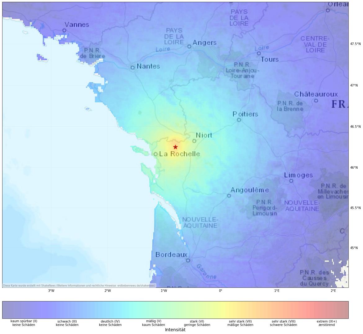
View earthquake, ShakeMap and historical seismicity on interactive map
Earthquake summary
A 5.5 magnitude earthquake hit La Rochelle, France on Friday evening. It was felt widely throughout Western France. According to the Geophysical and Detection Laboratory (LDG) France, the earthquake reached magnitude 5.9 with a shallower depth of 10 km. The epicenter of the earthquake was located in the west of France near the city of La Rochelle. It is one of the strongest earthquake recorded in that region since 1799.
It has an intensity of VI to VII and was therefore clearly felt throughout the region including Paris, Lyon and Normandy and reaching as far as south of England. Due to higher intensity, damage to infrastructure is very likely. The region around La Rochelle is one of the most seismically active regions in France. A series of larger strike-slip faults run across this region to Brittany. However, earthquakes over magnitude 5 are very rare.
Update 7:50 p.m: Modified Magnitude
The use of different scales has resulted in widely varying statements about the magnitude of the earthquake. The University of Strasbourg adjusted the earthquake to magnitude 5.3. It still remains one of the most powerful in recent decades. A residential chimney collapsed, as reported on Twitter. The extent of the damage is uncertain at the moment.
Des morceaux de pierre venant sans doute d’une cheminée sont tombés en centre-ville de #Niort. Les abords sont bouclés #seisme #DeuxSèvres pic.twitter.com/yNO8uJmLst
— France Bleu Poitou (@Bleu_Poitou) June 16, 2023
Update 9:10 p.m: Severe damage to buildings
The train traffic is interrupted in the region including the Paris-Bordeaux route. Extensive damage to a house in the Deux-Sèvres department and damage to the chimney is reported so far. Several roofs fell down in the village of La Laigne (west of epicentre) and cracks appear on the walls of many houses. In Mauzé-sur-le-Mignon, one person was also injured while trying to escape from the house during the quake. The earthquake also damaged high-voltage power lines leaving More than 1,100 people without power in the Charente-Maritime region. Severe damage to a church is also reported.
[irp]
Affected places
| City | Country | Intensity (EMS-98) | Population | Distance epicenter (km) | Description |
|---|---|---|---|---|---|
| Bussière-Poitevine | FR | 7.0 | 1000 | 8.2 | moderate damage |
| Saulgé | FR | 6.9 | 1100 | 15.3 | minor damage |
| Lathus-Saint-Rémy | FR | 6.8 | 1400 | 15.4 | minor damage |
| Lussac-les-Châteaux | FR | 6.8 | 2700 | 18.0 | minor damage |
| Usson-du-Poitou | FR | 6.6 | 1500 | 21.2 | minor damage |
| Poitiers | FR | 5.5 | 86000 | 51.0 | moderate, very minor damage |
| Limoges | FR | 5.2 | 141200 | 57.8 | moderate, very minor damage |
| Châteauroux | FR | 4.7 | 53300 | 92.8 | slight |
| Angoulême | FR | 4.6 | 49500 | 83.4 | slight |
| Niort | FR | 4.5 | 54700 | 97.3 | slight |
Current earthquake activity near Bussière-Poitevine:
In Bussière-Poitevine (map) 14 earthquakes larger than 4.2 were detected over the past 30 days. Therefore, the earthquake activity over the past month was much higher than usual (more than 20 % difference).
Summary of earthquake data:
FAQ: What are earthquakes? Which earthquakes are dangerous? How can you protect your famility and property?
What are faults and plates? Important terms explained.
General information about this earthquake:
Time: 2023-06-16 16:38 UTC
Magnitude: 5.5
Depth: 10 km
Felt: yes
Damage expected: --
Fatalities expected: --
Origin: tectonic
Links to all earthquake surveys in the world
Check out our Earthquake Impact Database to get all data for recent damaging earthquakes.
Earthquake data: GFZ
Statistic:
Since 1960 28 earthquakes larger than Magnitude 4.0 were detected in this region. The average number of earthquakes in this part of France (near Bussière-Poitevine) is 0.48 quakes larger than 4.0 per year. Therefore, the seismicity is usually moderate and quakes of magnitude 5.5 have a recurrence period of more than 50 years.
Strongest earthquakes in this area
| Date | Magnitude | Depth (km) |
|---|---|---|
| 1985-01-16 16:15 | 5.3 | — |
| 2005-04-18 06:42 | 5.2 | — |
| 2001-06-08 13:26 | 5.0 | — |
| 2019-03-20 09:56 | 4.5 | — |
| 2006-08-24 20:01 | 4.3 | — |
| 2005-06-22 19:41 | 4.3 | — |
| 1997-01-12 01:23 | 4.3 | — |
| 2022-05-09 11:13 | 4.2 | — |
| 1984-02-25 06:08 | 4.2 | — |
| 2016-05-02 10:36 | 4.2 | — |
*Data: USGS-Catalog (since 1960)